01
Document & prevent
Map outfalls, collect dated observations, review permits and inspections, and report active sediment discharges.
- Public records request
- Construction runoff reporting
- Independent depth/sediment assessment
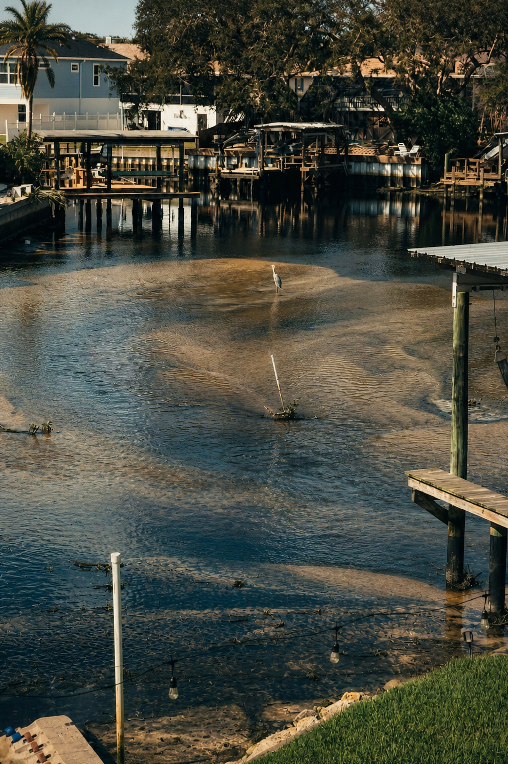
Neighbors are coming together to document sediment buildup, stop new runoff, and secure a fair plan to restore our canal.
A nonpartisan, neighbor-led effort. We follow the evidence.
One shared plan
Dredging is only a lasting solution when new sediment is controlled. Our work moves on two tracks at once.
01
Map outfalls, collect dated observations, review permits and inspections, and report active sediment discharges.
02
Press for a scoped, permitted, and funded restoration plan with responsibility assigned based on the facts.
What public records show
County and state records show years of work in the Klosterman Bayou system. They establish context and questions to answer—not responsibility for today’s sediment.
2008–10
Pinellas County commissioned a study of Klosterman Bayou and Joe’s Creek. It monitored the Innisbrook Canal/weir and described a history of elevated nutrients in the central watershed.
Read the County report2021–25
Public Works commissioned a Klosterman Bayou Watershed Management Plan, contract 190-0353-NC. Ask what it concluded for Baywood Village’s finger canals and which recommendations were adopted.
See the County planning process2020–24
Pinellas replaced bridges over the named Westwinds and Crosswinds canals. Project 000700A/000702A gives the group a precise starting point for construction and compliance records.
View bridge project detailsOngoing
FDEP has addressed bacteria and nutrient conditions in the larger Klosterman Bayou Run system. These records do not assess sediment buildup, but they support a need for coordinated water-quality attention.
Read the FDEP TMDLThe unanswered question
Twelve historical documents trace Baywood’s 2004–2007 navigational-dredging assessment effort and the County’s decision not to proceed. They give us a project-file lead—not a current survey, completed-project record, or finding about today’s conditions.
Read the Baywood history summary →Build the visual record
Historical imagery can show visible changes and help identify questions for inspection. It cannot, by itself, establish a sediment source or responsibility.
Use the County’s AIRS viewer for current and historic high-detail aerials. The PAIRS archive provides downloadable historic imagery dating back to 1926.
Open County imagery ↗ Flexible timelineSearch the canal, then use the historical-imagery clock to move through available dates. Coverage is helpful but not guaranteed every year.
Get Google Earth Pro ↗ Watershed contextUse Landsat for longer-term changes across the watershed and upstream development—not detailed proof in a narrow canal.
Explore USGS imagery ↗Florida success stories
See five documented Florida examples, the organizing and funding choices that helped, and public contacts who may be willing to share what they learned.
Take action today
Most important
Add your support and choose a way you can help. We’ll send only essential updates and meeting notices.
Sign up nowWhen you see runoff
From public property only, take wide and close photos/video. Note date, time, weather, location, and where water enters the canal.
Make your voice count
Ask the County for ownership, drainage, permit, inspection, sediment-assessment, and restoration-plan information.
Build momentum
Forward this site to someone who lives along the canal or uses it. A broad, factual group carries more weight.
A ready-to-use request
In the form, choose “File a Complaint – Alleged Construction without a Permit, Turbid/Silty Water, Sedimentation/Material/Debris being discharged on your property/Moving Dirt.” Use your own observation details and do not name a cause unless you have evidence.
Open the SWFWMD formDescription of inquiry
I am requesting SWFWMD review of potential sedimentation and stormwater-runoff impacts to the tidal canal behind homes near Gulfwinds Drive in Palm Harbor. Residents have observed shallow sediment accumulation and turbid or silty water conditions.
This inquiry does not allege that any specific person, project, or property caused these conditions. Please identify any relevant active or recent permits, inspections, complaints, enforcement records, or compliance requirements affecting this canal and its contributing drainage area. Please advise whether SWFWMD can inspect the area or coordinate with Pinellas County and Florida DEP, and provide a case number and recommended next steps.
Location: Tidal canal behind and near Gulfwinds Drive, Palm Harbor, within the Klosterman Bayou watershed. Relevant names may include Baywood Village Canal, Westwinds Canal, and Crosswinds Canal.
The right doors
Additional resources
For an active spill or environmental emergency, call the State Watch Office at 1-800-320-0519. This group does not make findings of fault; agencies and records do.
October 17, 2026 · County records update
Specific watershed findings, neighborhood drainage concepts, and a proposed committee plan for County board and staff conversations.
Read the findings and next steps →Open by design
Collect supporters, establish the evidence log, and choose a small steering team.
Identify ownership, drainage connections, permits, and prior maintenance plans.
Seek a written assessment, corrective-action schedule, and funding path.
Wear your support
Help spread the word with Baywood Canal Restoration shirts and everyday items. Net profits from our merchandise support the restoration effort.
Shop our Bonfire storeBrowse products, choose sizes and colors, and place your order on Bonfire. Opens in a new tab.
No-frills shirts to show your support for Baywood Canal.
Shop standard shirts 02 / HumorousA little canal humor to get the conversation started.
Shop humorous shirts 03 / PromotionalStart with our Baywood Canal coffee mug. More everyday items as the collection grows.
Shop the coffee mugAdd your voice
Sign up to receive campaign updates, meeting invitations, and specific ways to help. Your information stays with this local effort.
Use our shared sign-up form to receive updates and choose how you would like to help. Responses are available to the organizers of this local effort.
Open the sign-up formThe form opens in a new tab and is managed by Baywood Canal Restoration organizers.